Paekākāriki has a rich and diverse history
For a wonderful potted history with many links to rich stories visit the Station Museum page.
Excellent historical displays are found at the Station Museum and at Mackays Crossing at the US Marines Memorial and Tramway Museum.
Local author Michael O’Leary has written an excellent short history of the village. This can be heard read in three parts by local actors:
For Preservation
Jenny Clark writes about the heritage of our Beach Road buildings and the merit in saving them.
(Station Museum – Beauchamp Collection)
Paekākāriki is a village in every sense of the word. Its geographical position — bounded by steep hills, the ocean and Queen Elizabeth Park — make it a distinct entity, unlikely to be extended in any direction.
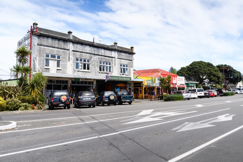
Holtom’s Building and adjoining shops are a familiar landmark in Paekākāriki. They are the first buildings you see as you cross the railway line and come into Beach Road. Sadly, the historic hotel on the other side of Beach Road was demolished some years ago. The remaining Beach Road shop buildings are what distinguish Paekākāriki from other towns on the Kāpiti Coast.
The Paekākāriki General Store is the oldest of the three shop buildings on the south side, being built about 1900. The original store was owned by Mr Leighton Short. Mr Short’s store was built from native timbers, with a matai floor and tongue-and–groove ceiling. As the General Store it retains its 120 year-old character. A portion of the building now serves as the Paekākāriki Fruit Supply.
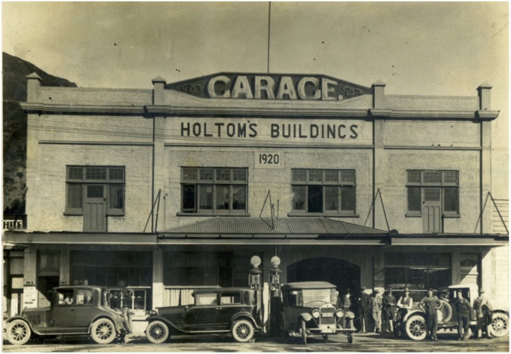
Holtom’s Building — being two-storied and the first building across the railway line — is the most prominent of the block. Its facade is dated 1920 in an art deco font. Architecturally, it’s an example of 1920’s town concrete architecture. It originally included a billiard parlour upstairs with shops downstairs. The garage was built by Mr Frank Holtom to serve the motoring public who needed tyre changes and petrol. He spotted a business opportunity with the growing number of automobiles making the trip over the Paekākāriki Hill Road to visit the beaches on the Kāpiti coast.
The building between Holtom’s and the General Store is occupied by the Perching Parrot Café, also built early last century. Together these buildings form an uninterrupted strip of historic streetscape, now rare to see in the Kāpiti region.
The south side of Beach Road still looks today as it did almost 100 years ago, particularly given St Peter’s Church on the hill (designed by Frederick de Jersey Clere) and the 100 year-old village hall. The town still has many 100 year-old cottages. Early subdivision maps from 1907 show the development of building sections as Paekākāriki was touted as a charming seaside retreat from Wellington.
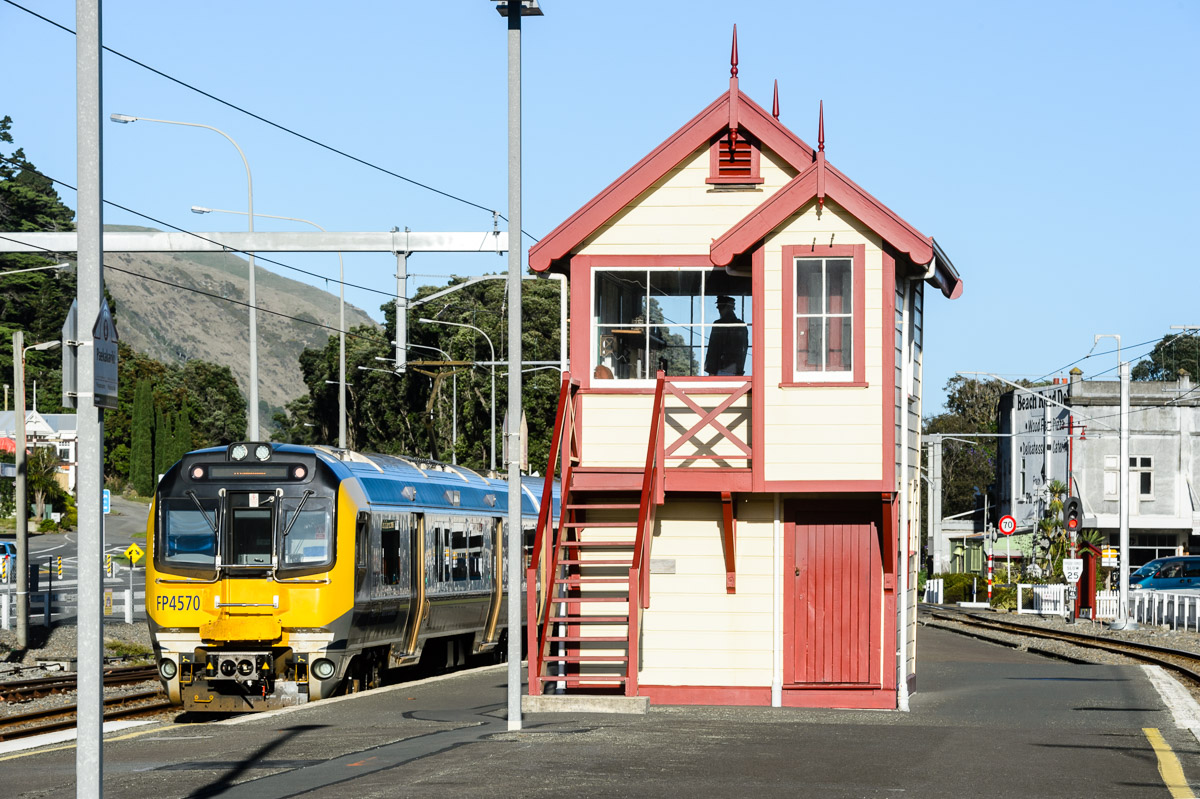
Paekākāriki’s historic railway precinct is to the north of Beach Road, and alighting passengers walk down the platform to arrive at the Beach Road shops which readily form part of Paekākāriki’s wider historic precinct.
The shops have had modifications to the facades. However, Holtom’s Building looks much the same today as it did when it was first built. The walls are concrete, with tongue-and-groove lining and ceilings. Original features are easy to spot. There is cosmetic modification to the façades of the shops, but the interiors remain much the same as when they were first built.
Holtom’s Building needs strengthening to bring it up to an acceptable level of earthquake resistance, but an engineer’s report shows that this is feasible and well within reasonable costs, and should give the building at least another 50 years.
The other buildings are showing their age, but ongoing repairs and maintenance give them many years of useful life.
A submission has recently been made to the Kāpiti District Council and to Heritage New Zealand to have these buildings recognised as worthy of preservation.
A bit of history
An early reference to Paekākāriki as a place where people lived is in the 2008 Pātaka Museum publication North Road: Revisiting the map of the road from Johnsonville to Paekākāriki drawn by Thomas Henry Fitzgerald in 1849. The book talks about Scotch Jock Nichols and his wife, Kahe Te Rau-o-te-rangi, known as Betty Nichols. Kahe Te Rau-o-te-rangi is the famous wahine who swam to the mainland from Kāpiti Island with her baby strapped to her back to warn her people of an impending attack by another iwi.
The Nichols’ had a liquor licence and ran an accommodation house at Paekākāriki during the years after 1847. Betty Nichols is particularly relevant to the story of Beach Road, because she owned a strip of land from the railway line to the sea, along Beach Road, that included the land up to Finn’s Hotel, and the now privately-owned building that used to be the Paekākāriki post office. There is no documentary evidence, but the fact that the Paekākāriki post office on Beach Road was on what had been Betty’s land, shows a direct connection to Māori-owned land used for public purposes — a common practice in the 19th and early 20th centuries. The post office was sold to a former post office staff member when the post office was closed several years ago, and is now a second‑hand shop.
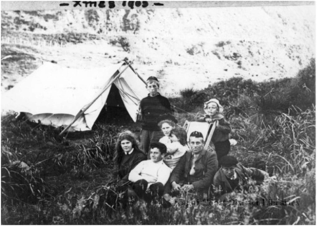
The building of the Paekākāriki Hill Road in 1846 and the railway line in the 1880s gave reasonable access to and from Wellington. Photos and material from the Kāpiti library’s archives show a settlement growing into a small town. Advertisements in 1905 and 1907 for subdivision of land for beach houses talk of ‘lovely warm sandy beaches… Its mountain road, with its glorious panorama of sea and sky, presents features of beauty and interest that cannot be surpassed in any part of the world!’ People bought seaside sections and families came in the summer to camp.
The story of this early development features in Paekākāriki: A Short History by Michael O’Leary (Paekākāriki Station Museum, 2014)
Paekākāriki School was built after the coming of the railway in 1886, showing the increasing popularity of the region. The Paekākāriki Railway Station’s current building was designed by railway architect George Troup and was built in 1910. It forms part of Paekākāriki’s historic railway precinct.
Two grocery shops served the burgeoning population; Mrs Kidd’s store in Robertson Road, and Leighton Smith’s shop in Beach Road. Photos from 1905 show the Beach Road grocery store and the small building next to it. This grocery store has supplied local residents with their groceries for well over 100 years.
A post office had been opened in 1869 in the Paekākāriki Hotel, the first postmasters being innkeepers. After a period in the railway station a permanent building was erected in 1907 in Beach Road. This small building was replaced in 1925 by the building that still stands on the north side of Beach Road today.
-
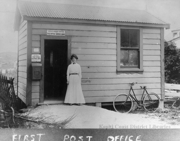
The first Post Office and Postmistress, 1907 (Alexander Turnbull Library) -
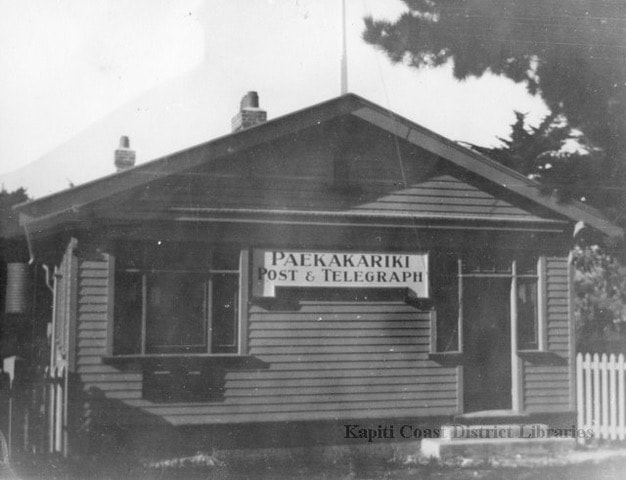
The ‘new’ post office in Beach Road, opened in 1925, (Alexander Turnbull Library)
There are photographs and advertisements for a variety of shops in Paekākāriki. On the north side of Beach Road was Carson’s Chemist and a butcher’s shop in the building next to the Post Office. Beckett’s haberdashery became a tattoo parlour and then a tailor-made jeans workshop in later life. The Commercial Bank of Australia occupied the tiny shop on the right of the building, later becoming a rock shop, a florist and then a real estate office.
On the corner of Beach Road by the railway line was the Paekākāriki Hotel. This was the site where Scotch Jock and Betty Nichols had the first pub, on Betty’s land. There has been a succession of pubs on the site and the hotel has always been at the heart of Paekākāriki’s community. It is now Finn’s Hotel and includes a restaurant, a bottle store and accommodation.
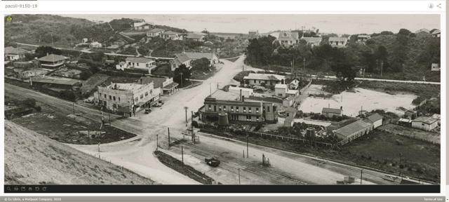
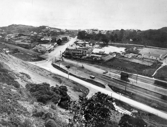
View over Beach Road in 1929. Showing the Paekakariki Hotel, the general store and Holtom’s Buildings with the tiny chemist shop beside it. (Alexander Turnbull Library)
In fact for a long time the hotel was the only liquor outlet on the Kāpiti Coast. In 1921, at the marriage of Takiri Eruini to Matiu Love in Paraparaumu, the beer was fetched from the Paekākāriki Hotel in milk cans for the celebrations.
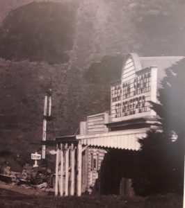
Holtom’s Buildings in Beach Road sports the date 1920, but only the ground floor was completed by then. It wasn’t until 1922 that the first floor was finished (the story is that the builders ran out of concrete). Mr Holtom celebrated the opening with advertisements proclaiming the virtues and amenities of his new building. In addition to the servicing of motor vehicles, and provision of ‘motor spirit’, his wife, Mrs Emma Holtom, ran a tea room on the left of the ground floor, and there was a billiard room upstairs with splendid new billiard tables. Later a new floor was laid down in the billiard room and it was converted to indoor bowling. After that it became a sewing factory. These days it is occupied by artists’ studios and Alan Wehipeihana’s gallery. Beside the tea room in a lean-to building was Mr William Carson’s first chemist shop, right next to the railway line.
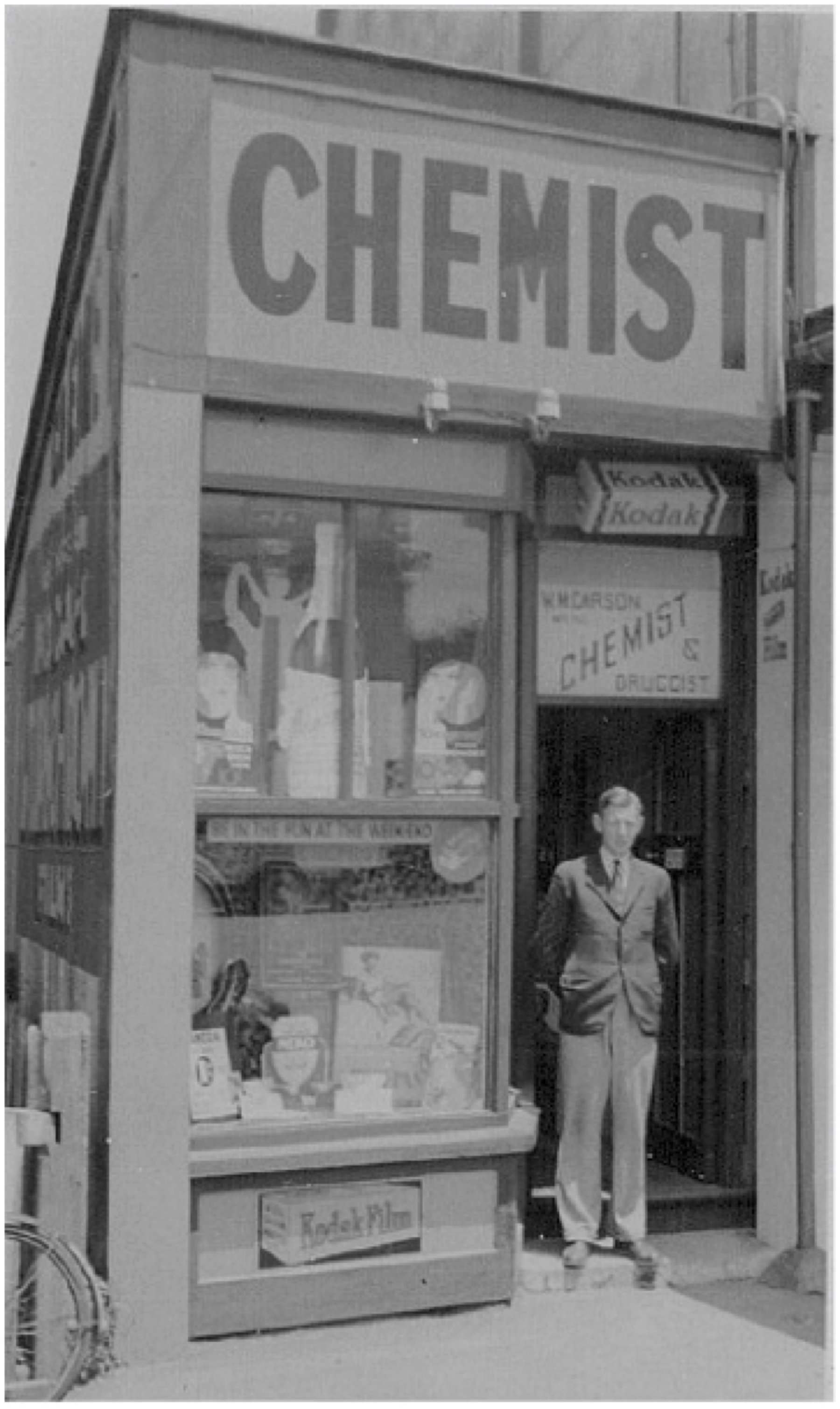
William Carson’s first chemist shop, between Holtom’s and the railway line. (Station Museum – Carson Collection )
For many years Carson the Chemist was the only one on the Kāpiti Coast with the next nearest being in Levin. Residents from Plimmerton used to give their prescriptions to the guards on the passenger trains who would deliver them to Mr Carson, and the guards would return the filled script to Plimmerton. For people in Paraparaumu the New Zealand Railway bus drivers used to bring the prescriptions down to Mr Carson and then pick them up again and return the items.
By 1933, Paekākāriki had expanded and several Beach Road shops had changed hands. Holtom’s garage had become Watkins & Co, Leighton Smith’s general store was being run by G. Barnett. Holtom’s tearooms were still selling sandwiches, cakes and ice cream.
In 1935 parts of Beach Road and Wellington Road were both lowered, making the access to the beach relatively level, and leaving St Peter’s Church high up on the south side of Beach Road.
1937 saw the beginning of the construction of the Centennial Highway and associated seawalls, bringing workmen and change to Paekākāriki. A small hairdressing shop was moved to make way for the new road, and the Bly’s shellcrushing business, sitting on the site for the new intersection, disappeared. The Highway opened in 1939.
The Second World War brought the US marines to Paekākāriki. They built a huge camp in Queen Elizabeth Park. Soldiers would walk in to Paekākāriki to visit the pub, and for social events at St Peters Hall in Beach Road.
Today
Today, Beach Road is the heart of Paekākāriki. The two cafés are often full of people enjoying coffee and a snack in the sunshine, the oldest garage on the Kāpiti Coast is still there in the middle renting out trailers, and fixing cars. The general store, run by Amrit Morar and his son Bhavesh, stocks almost anything anyone needs in the way of groceries. There is a well-stocked greengrocer next door. Over the road, the old Post Office serves as a secondhand store; while the very old one-storied three-shop block that used to be the chemist, haberdashery and bank is currently empty, awaiting some kind of development. There is a hairdresser in the small shop next to the Finn’s Hotel.
All these small shops, along with historic St. Peter’s Church and the 100 year-old St Peters Village Hall, are well-recognised and valued by Paekākāriki residents and indeed the Kāpiti Coast community. There is nowhere else in the Kāpiti region that has kept so much of the character of the early settlements.
Paekākāriki will face a new era with the opening of Transmission Gully in 2020. We can take advantage of the opportunity presented by having easier vehicle access from the main road in and out of Paekākāriki, and the likelihood of visitors making Paekākāriki a destination with the ease of getting off the new SH1 at Mackays Crossing. The escarpment track already makes Paekākāriki a popular tourist spot. We have a wonderful train service, which serves foot traffic as well as the cyclists who come to ride around the tracks in Queen Elizabeth Park. Paekākāriki is a welcoming sight for visitors, and our efforts to preserve our heritage will also benefit local businesses.
Small towns in New Zealand need all the help they can get to remain viable. As Frank Holtom recognised early last century, Paekākāriki has the advantage of being close to Wellington. With its convenient railway station, and the new highway making access even easier, a listing with Heritage New Zealand would encourage local shopkeepers and the community in their efforts to keep their village vibrant, while being a living reminder to others of how New Zealanders lived in the 1900s. And Paekākāriki is a real town, not a museum!
The Paekākāriki community is proud of its heritage. I think it’s fair to say that the owners of Beach Road buildings have the support of the people who live in Paekākāriki to preserve and restore the character of these properties. How we can help is something for us to think about.
If you have your own stories of early Paekākāriki, let us know! [email protected]
Lake Hallow: A Village Pond with Spears, Bones and Pleasure Boats
Friday 30 August, 2019 / Fiona Gunter Firth
Waterways once reached from Paekākāriki to Waikanae and it was said the waterways between the sandhills were so numerous that canoes could be paddled between the settlements.
In 1855 an 8.2 earthquake, centred in the Wairarapa, radically changed these waterways. The area was uplifted between 1 to 1.8 metres, reducing the local rivers of Wainui and Whareroa to just streams, making the waterways less navigable.
The European settlers then drained more of the swamp areas to create roads and the railway in the 1890s. However, there remained at Paekākāriki a large pond. Early Pākeha settlers named this area of water Lake Hallow.
In 1895 the pond was drained for Mr Slight, the Paekākāriki Hotelier. Found were a human skull, bones and a carved steering paddle, evidently part of a Māori war canoe.
Old settlers at this time were reported to have said the bones probably belonged to a murder victim from the 1840s when whalers and local Maori would drink and fight in the area. The pond was said to have not been dry for 40 years.
https://kapiticoast.pastperfectonline.com/photo/86DEEB6D-683C-4D17-A836-282508534410
An 1888 survey map identifies a ‘Pond with Spears’ at the site of the village.
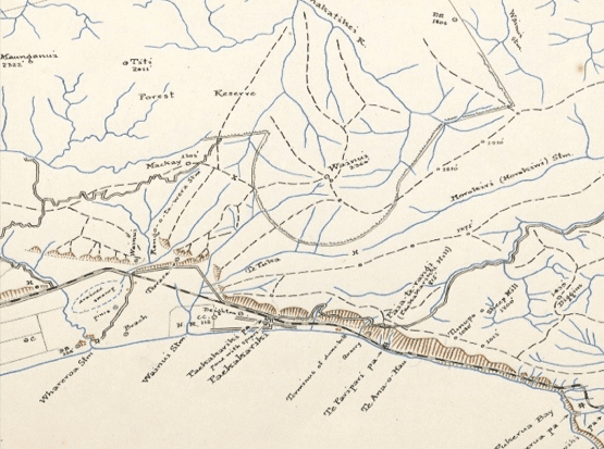
To whom did these spears belong? Was the pond drained on another earlier occasion or could the reference be from when the waterways were drained after the earthquake?
Moa were hunted in the area over 400 years ago, evidence of this was found in the sand dunes in the area. Could the spears have belonged to the tribes who hunted wetland birds and fished in the area between 1600 to 1700?
At the beginning of the nineteenth century, the Kāpiti Coast was generally occupied by the Muaupoko and Ngāti Apa peoples.
From 1819 a series of migrations to the western coast from Kawhia and Taranaki occurred and brought the groups Ngāti Toa, Ngāti Mutunga, Ngāti Tama, Te Atiawa, Ngāti Raukawa and several others to different places around the district, including the establishment of the Wainui pa with Ngāti Haumia. As there is little detail of the spears found they could have belonged to any of the above tangata whenua.
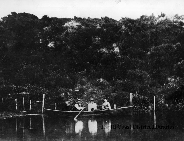
Local settlers and visitors to the hotel used to entertain themselves by boating on the lake. In this 1902 image the man rowing is either Charles Slight, the hotel’s original publican or Charles Tilley the second hotel publican. The women are unidentified but may be family members.
In 1932 the pond was drained completely to create the village Bowling Green, still in use today.
In 2003 the village was hit by a weather bomb and a deluge of water swept down from the hills above, flooding the low-lying area of the village shops and surrounding streets.
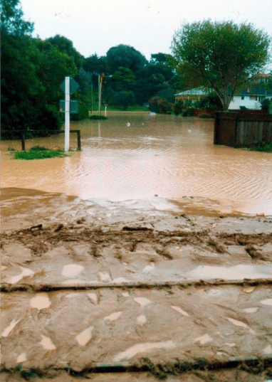
Damage was such that the village was isolated for 3 days, with no way in or out by road or rail. Twenty homes were flooded and evacuated. This image shows the water still present the next day.
Even now the bowling green occasionally floods and the remnants of Lake Hallow emerge.